印度的大小和位置
印度是世界上最早的文化之一,有着非凡的历史。在 50 年期间,它取得了综合的社会经济进步。它在农业、工业、技术和整体经济发展等部门都取得了非凡的进步。印度也创造了世界历史的非凡成就。
印度的位置
印度是一个幅员辽阔的国家,也是世界第七大国。它完全位于北半球。大陆在纬度(8°4' N 和 37°6' N)和经度(68°7'E 和 97°25'E)之间扩张,北回归线(23°30'N)将该国分裂成近大陆东南和西南两个相等的部分,位于孟加拉湾和阿拉伯海的安达曼和尼科巴群岛和拉克沙德维普群岛。
印度联盟的最南端——英迪拉点在 2004 年的海啸中被海水淹没。印度大陆北起克什米尔,南至坎亚库马里,东至阿鲁纳恰尔邦,西至古吉拉特邦。印度的领土界限进一步延伸到距海岸12海里(约21.9公里)的海域。当我们谈论印度的纬度和经度时,它们大约是 30 度。而实际测得的南北极端距离为3214公里,东西两极只有2933公里。从纬度的值,它被理解为-
- 这些国家的南部地区位于热带地区。
- 北部处于亚热带或暖温带。
Time Difference
From the values of longitude, it is quite discernible that there is a variation of nearly 30 degrees. it causes a time difference of nearly two hours between the easternmost and the westernmost parts of our country.
Concept of IST and GMT
- IST stands for Indian Standard Time. It is based on longitude 82.5° which passes through Mirzapur near Allahabad in Uttar Pradesh.
- GMT stands for Greenwich meantime. The world clock works on basis of Greenwich meantime. It passes from London and is set according to meantime.

印度的大小
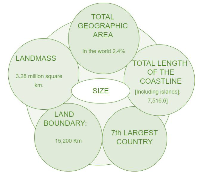
The landmass of India has an area of 3.28 million sq. km and it equals 2.4% area of the world making the India 7th largest country. But before India, there are 6 more largest countries – Russia, Canada, U.S.A, China, Brazil and last one in Australia.
以下是与印度大小相关的一些要点和特点:
- 印度国境线长15,200公里,海岸线长7,516.6公里,从印度开始向北到东北有许多最大的山脉,称为喜马拉雅山脉。
- 在南部,如果我们从北到南谈论印度大陆,则有一个印度洋,之间的差距是 3214 公里,如果我们谈论东西之间的差距是 2933 公里,那为什么由于与阿鲁纳恰尔邦的差距邦到古吉拉特有两个小时的时差。
- 在阿鲁纳恰尔邦,清晨两小时日出,所以我们所有印度人都遵循印度标准子午线,这可以保持所有印度和印度标准子午线穿过北方邦米尔扎普尔的相同时间。
- 当一个人从南向北移动时,纬度范围会影响白天和黑夜的持续时间。

示例问题
问题一:给出印度的重要地理点。
回答:
The mainland expands between latitude (8°4′ N and 37°6′ N) and longitude (68°7’E and 97°25’E) and the tropic of cancer (23°30’N) cleft the country into near two equal parts to the southeast and southwest of the mainland, lies in the Andaman and Nicobar Islands and the Lakshadweep Islands in the Bay of Bengal and the Arabian Sea.
问题 2:说出世界上最大的七个国家。
回答:
The seven largest countries in the world are: Russia, Canada, U.S.A, China, Brazil, Australia and India.
问题 3:Kanyakumari 几乎感觉不到昼夜持续时间的差异,但在克什米尔则不然。为什么?
回答:
Kanyakumari is closest to the equator and latitude extended influence in the duration of day and night as one move from south to north. at that period day and night difference comparatively becomes wider because in the south there is a part of Kanyakumari and it closer to the equator that why we can’t see the difference but if it moves towards the north the difference will be more obvious.
问题4:描述经度和纬度。
回答:
- Longitude – Vertical mapping lines on earth line longitude as known as meridians. one simple way to visualize this might be to think about hula hoops cut in half, vertically positioned with one end at the North pole and other at the South pole.
- Latitude – Horizontal mapping lines on earth are lines of latitude known as a parallel of latitude because they run parallel to the equator one simple way to visualize this might be to think about having imaginary horizontal hula hoops around the earth.
问题五:印度的地理位置如何有利于国际贸易?
回答:
India’s geographical location is favourable for international trade as,
- Due to the central location at the head of the Indian ocean, countries of East Africa, West Asia, East Asia could be reached through the sea routes.
- India is connected with Europe, North America and South America through both routes – the cape of good hope and the Suez canal.
- India is favourably located on the world’s highway of trade and commerce both to the east and the west.
- Unlike landlocked countries, it has easy access to the outside world. the ocean routes from East and South as, East Asia and Australia to Africa pass through the Indian ocean.