Unfolding是一个库,用于在Processing和Java创建交互式地图和地理可视化。在本文中,我们将讨论展开的功能以及如何使用它在Java和Processing中创建交互式地图。
使用展开的主要目的是不仅要在Java和处理过程中创建静态映射,而且还要创建交互式映射。通过从官方网站下载展开模板,可以轻松地将其安装在eclipse上。由于展开提供的功能而被广泛使用,例如:
- 互动事件:在展开过程中,我们可以轻松创建互动地图。该库中包含诸如缩放和平移之类的基本交互。除此之外,还可以轻松地将更高级的功能(例如概述,详细信息或多点触摸手势)添加到地图中。
- 数据可视化:该库非常强大,甚至可以让用户创建地理位置标记以在地图上显示数据。这种视觉风格可以自由调整。该库还支持用户加载和显示用户定义的形状,例如点,线或多边形。
- 样式化地图:此库是基于标题的地图库。该库允许地图标题具有各种地理特征和样式。它还提供了诸如OpenStreetMap或TileMill之类的地图提供程序。
- 干净且可扩展的代码:该库使初学者可以轻松创建简单的地图。高级用户还可以绘制其原型草图或创建自己的复杂可视化效果。
方法:
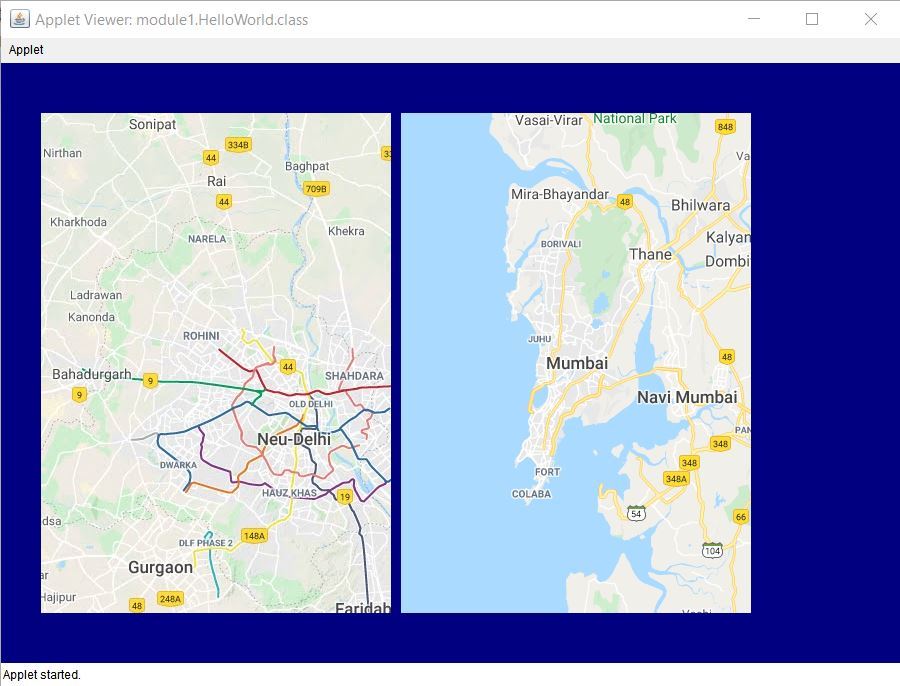
在此实现中,我们考虑使用此库绘制两张地图,一张是德里,另一张是孟买。创建的地图是交互式的,因为我们可以放大和缩小。我们需要使用该地点的经度和纬度来设置地图。程序中的绘制函数重复运行,并在画布上重复绘制地图。
下面是上述方法的实现:
// Java implementation of using
// unfolding maps

// Importing the libraries in eclipse
import processing.core.PApplet;
import de.fhpotsdam.unfolding.UnfoldingMap;
import de.fhpotsdam.unfolding.geo.Location;
import de.fhpotsdam.unfolding
    .providers.AbstractMapProvider;
import de.fhpotsdam.unfolding
    .providers.Google;
import de.fhpotsdam.unfolding
    .providers.MBTilesMapProvider;
import de.fhpotsdam.unfolding
    .utils.MapUtils;

// Class to make the map
public class MakeYourMap extends PApplet {

    // To keep eclipse from reporting
    // a warning
    private static final long
        serialVersionUID
        = 1L;

    // Initializing the height and
    // width of the map
    private static int mapWidth = 350;
    private static int mapHeight = 500;

    // This map is used to display Mumbai
    UnfoldingMap map1;

    // This map is used to display Delhi
    UnfoldingMap map2;

    // Function which implements the unfolds
    // library
    public void setup()
    {
        // Set the Applet window to be
        // 900x600 width and height.
        // The OPENGL argument indicates
        // to use the Processing
        // library's 2D drawing
        size(900, 600, P2D);

        // This sets the background colour
        // for the Applet. Here, colour
        // blue is choosen
        this.background(0, 0, 128);

        // Select a map provider.
        // Here we are using google provider
        AbstractMapProvider provider
            = new Google.GoogleTerrainProvider();

        // Set a zoom level to focus on
        // our specified location
        int zoomLevel = 10;

        // Creating the first map
        map1 = new UnfoldingMap(
            this, 40, 50, mapWidth,
            mapHeight, provider);

        // This line zooms in and centers
        // the map at 28.7041 (latitude)
        // and  77.1025° (longitude) for Mumbai.
        map1.zoomAndPanTo(
            zoomLevel,
            new Location(28.7041f, 77.1025f));

        // This line makes the map interactive
        // as we can zoom in and out. And, here
        // we have zoomed our focus to the
        // Mumbai location by setting the
        // zoom level to 10.
        MapUtils
            .createDefaultEventDispatcher(
                this, map1);

        // Creating the same map for
        // Delhi
        AbstractMapProvider provider2
            = new Google.GoogleMapProvider();

        map2 = new UnfoldingMap(
            this, 40 + mapWidth + 10, 50,
            mapWidth, mapHeight, provider2);

        // 19.0760 (latitude) and
        // 72.8777 (longitude) are for Delhi
        map2.zoomAndPanTo(
            zoomLevel,
            new Location(19.0760f, 72.8777f));

        // This line makes the map interactive
        MapUtils
            .createDefaultEventDispatcher(
                this, map2);
    }

    // Function to draw the applet window
    public void draw()
    {
        // The draw method is implemented
        // repeatedly by drawing our maps
        // again and again on the canvas
        map1.draw();
        map2.draw();
    }
}
输出:运行上述代码时,将获得以下输出: 